
We often look to the stars when we think of the great unknown, completely ignoring the alien world that covers 71% of our own planet. The ocean is the engine of the global climate, the primary source of protein for billions, and the critical buffer against atmospheric warming. Yet, historically, we have mapped more of the surface of Mars than we have the topography of our own ocean floor.
The primary barrier has always been physics: saltwater blocks electromagnetic waves, meaning Wi-Fi, GPS, and standard radar are useless underwater. The crushing pressure of the abyssal zone turns standard engineering into scrap metal. Today, however, Oceanography is undergoing a massive technological renaissance. Driven by advanced robotics, artificial intelligence, and revolutionary acoustic networking, "OceanTech" is finally piercing the darkness, turning the ocean from a vast, unknowable void into a deeply quantifiable, data-rich ecosystem.
Autonomous Underwater Vehicles (AUVs) and Untethered Robotics
The days of scientists dangling limited sensor packages over the side of a ship on miles of steel cable are ending. The vanguard of modern oceanography is the Autonomous Underwater Vehicle (AUV).
- Tether-Free Exploration: Unlike Remotely Operated Vehicles (ROVs), which require a physical tether to a surface ship for power and human control, AUVs are completely autonomous. Powered by advanced lithium-polymer batteries or even wave-energy harvesting buoys, these torpedo-shaped robots can glide silently through the depths for months at a time.
- Swarm Intelligence: Oceanographers are deploying "swarms" of dozens of small, interconnected AUVs simultaneously. Using acoustic modems to communicate with each other through the water, these swarms can rapidly survey hundreds of square miles of ocean, hunting for specific chemical signatures like deep-sea hydrothermal vents, underwater methane seeps, or localized oil spills.
- AI Navigation: Because GPS doesn't work underwater, AUVs rely on advanced inertial navigation systems paired with AI. The onboard computer constantly calculates its position by referencing its starting point, speed, and heading, occasionally pinging the seafloor with Doppler velocity logs to correct its internal map in real-time.
High-Resolution Mapping and Seabed 2030
The Nippon Foundation-GEBCO Seabed 2030 project is an ambitious global initiative to map 100% of the world's ocean floor by the end of the decade. Technology is the only way this is achievable.
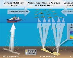
- Multibeam Echosounders: Modern surface vessels and deep-diving AUVs are equipped with advanced multibeam sonar. Instead of sending down a single "ping," these systems project a wide, fan-shaped acoustic pulse, receiving thousands of data points back per second.
- Centimeter-Level Resolution: This technology creates incredibly dense, 3D point-cloud maps of the ocean floor. We are moving from maps where an entire underwater mountain range might be a blurry blob, to maps with centimeter-level resolution, revealing ancient shipwrecks, deep-sea coral reefs, and the exact contours of tectonic fault lines critical for tsunami prediction.
Marine Biotelemetry: The "Internet of Turtles"
To understand marine ecosystems, scientists must track the animals that live within them. Technology has turned marine megafauna into active data-collection nodes.
- Miniaturized Tagging: Scientists attach small, non-invasive telemetry tags to sharks, sea turtles, whales, and even deep-diving seals. These tags have shrunk from bulky, heavy boxes into highly streamlined micro-computers equipped with GPS (for when the animal surfaces), accelerometers, depth pressure sensors, and thermometers.
- Biological Oceanographers: As these animals migrate across thousands of miles and dive to extreme depths, the tags record the exact temperature and salinity of the water column. When a tagged Great White Shark surfaces, its tag transmits months of this environmental data via satellite back to researchers, effectively turning the animal into a highly mobile, biological oceanographer collecting data in harsh environments (like under Antarctic sea ice) where human robots cannot easily go.
Digital Twins and Climate Modeling
The ocean absorbs roughly 30% of all carbon dioxide emissions and 90% of the excess heat generated by global warming. Understanding this process is the most critical component of climate science.
- The Digital Twin of the Ocean (DTO): Researchers are building massive, supercomputer-powered simulations of the global ocean. By feeding these digital twins continuous, real-time data from AUVs, satellite sea-surface altimetry, and biotelemetry tags, AI models can simulate the fluid dynamics of the entire global current system.
- Predicting Systemic Shifts: This massive data integration allows scientists to track the slowing of the Gulf Stream, forecast the exact severity of El Niño weather patterns months in advance, and map the precise spread of ocean acidification, providing policymakers with the undeniable data required to protect marine sanctuaries and manage global fisheries sustainably.
The Outlook
Technology is granting us the eyes and ears required to understand our planet’s life support system. By combining autonomous robotics with massive data analytics, oceanography is transitioning from an era of blind sampling into an era of persistent, systemic understanding, giving humanity a fighting chance to protect the blue heart of our world.




Comments